
Intern Simona Taronna Writes an Update from the Field
9:00 am and the little parking lot by the “No Trespassing” North Salt Spring Waterworks District sign on Maxwell Road is packed. There is excitement in the air as an eclectic group of ecologists, foresters, restoration experts, technicians, students and volunteers gather in the field. It is day one of baseline data collecting at the Maxwell Watershed for Transition Salt Spring.
With special permission, we make our way through the forest following GPS coordinates to the first of 40-sample plots, expertly selected and set up throughout the watershed. Our mission: record baseline data on the Maxwell catchment basin, which provides about 35% of the increasingly precious fresh water supply to Salt Spring citizens and tourists.
As a Restoration of Natural Systems UVic student, I could not believe my luck when I was offered this short-term data collecting position. After months of restoration theory, I finally have an opportunity to immerse myself in fieldwork on this beautiful Gulf Island, learning from the experts. I will make a small contribution to an ambitious and innovative multifaceted project aiming at protecting an at-risk freshwater reserve amid a growing climate emergency.
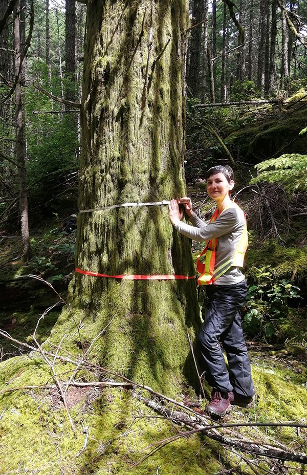
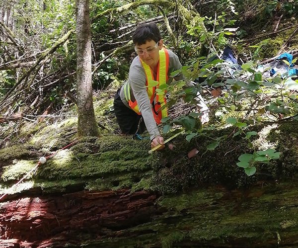
We reach the first plot, and my partner and I start setting up the north-south and east-west transect lines. “You will be measuring fine and coarse woody debris and trees’ basal area”, I was told. In other words, we count dead sticks, branches and wood laying on the forest floor, and we measure the density of trees at each site. We also record shrubs’ species and cover, count saplings and seedlings, and analyze the forest floor. It is meticulous detective work, and we patiently and systematically go through our tasks while hordes of mosquitoes feast on us. Afterwards, we pause to look around and try to “understand” each forest site. What natural and human-caused disturbances it has experienced, what it might have looked like in the past, and where it is headed. We look up at the canopy, we peer through the thickets, we examine herbs, forbs and shrubs, and we listen to bird calls and cicada-like sounds. What we do not see, just below our feet, is just as important as what we see: the soil, the roots, the mycorrhizal network, the insects, the microbes, the nutrients and minerals, and –flowing through it all– the precious water.
Why go to all this trouble? Why not just let the forest be? After all, this area is already off-limits to protect the watershed from damaging recreational activities. Nature is resilient, and if given enough time, it often surprises us with its adaptability and tenacity. But the pressure is mounting, and the demands on this watershed are increasing. Past forestry and agricultural management practices have deeply affected the watershed and altered its hydrology. These factors, coupled with climate change effects, have dramatically increased the risk of drought, wildfires, flooding, and loss of biodiversity. If we invest time now in watching, recording, and listening to the forest, we can use this precious information to build a more resilient watershed for the challenging years ahead.
What does a resilient watershed look like? A watershed is like a puzzle, and its resiliency depends on the health of each component. If one piece is missing or suffering, the entire watershed is at risk. All elements are connected and interdependent. As we measure woody debris, fuel load and trees, we also look at topography, watercourses, drained wetlands, soil and signs of erosion, species and age diversity, the health of the understory, wildlife habitat, and signs of regeneration. An overgrown stand of even-aged and single-species trees over bare ground does not often equate to a healthy forest. Healthy forest ecosystems tend to be messy looking, rich in species and age diversity, buzzing with insects and birds, carpeted in decaying wood colonized by bugs, mycelium and mushrooms. Shady areas of dense mature stands are interspersed with pockets of open canopy, where abundant light favours a thick understory and the growth of new saplings. Such complex mosaic and diversity are what we should be striving for and what a restored Mt. Maxwell watershed forest would look like.
As I listen to the rain falling outside my window, I imagine the path of raindrops at Maxwell watershed. As they break their fall hitting the forest canopy, what will they encounter next? Will they meet an understory of ocean spray, salal, and Oregon grape? And after that, will the trickling rainwater encounter spongy, mossy and humus-rich ground? Will there be healthy roots and rotting wood to absorb the moisture? Or will the rain hit the bare ground and quickly run off, causing flooding and erosion, washing sediments into the watershed or rapidly draining and disappearing?
The key to watershed resilience is its capacity to slow the water down and let it linger and interact with the land. Vegetation, decomposing debris, healthy riparian zones and wetlands act as sponges retaining water, filtering it, and slowly releasing it into streams and lakes. A “slow water” movement is quickly gaining ground, inviting us to rethink our relationship with water in terms of respect and cooperation after decades of commoditization and control efforts.
It is a win-win situation. By restoring the health of the forest, we will improve the quantity and quality of our water, increase biodiversity and restore natural processes, reducing the risk of wildfires and protecting Salt Spring natural assets and properties for years to come.